


Chidrac Clemensat Meilhaud 20 km dénivelé 450

jeanic63
User
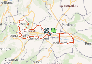

Length
20 km

Max alt
772 m

Uphill gradient
468 m
Km-Effort
26 km

Min alt
432 m

Downhill gradient
468 m
Boucle
Yes
Creation date :
2025-03-15 15:44:19.262
Updated on :
2025-04-07 17:01:42.035
5h58
Difficulty : Medium

FREE GPS app for hiking
 SityTrail
IGN / Geographical institutes
SityTrail Plus
The world is yours!
About
Trail On foot of 20 km to be discovered at Auvergne-Rhône-Alpes, Puy-de-Dôme, Chidrac. This trail is proposed by jeanic63.
Description
départ Chidrac 63 vers le restaurant le clos ou nous avons mangé
Positioning
Country:
France
Region :
Auvergne-Rhône-Alpes
Department/Province :
Puy-de-Dôme
Municipality :
Chidrac
Location:
Unknown
Start:(Dec)
Start:(UTM)
511651 ; 5044194 (31T) N.
Comments