


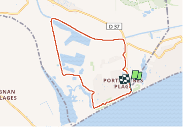
boucle au départ de Portiragnes Plage

Daron34
User

Length
8.2 km

Max alt
10 m

Uphill gradient
39 m
Km-Effort
8.7 km

Min alt
-2 m

Downhill gradient
38 m
Boucle
Yes
Creation date :
2025-03-15 14:10:36.449
Updated on :
2025-03-15 16:17:12.372
1h57
Difficulty : Very easy

FREE GPS app for hiking
 SityTrail
IGN / Geographical institutes
SityTrail Plus
The world is yours!
About
Trail Walking of 8.2 km to be discovered at Occitania, Hérault, Portiragnes. This trail is proposed by Daron34.
Description
boucle de 9kms au départ du bord de mer de Portiragnes Plage en traversant l étang de la rivièrette puis en longeant le Canal du Midi
Positioning
Country:
France
Region :
Occitania
Department/Province :
Hérault
Municipality :
Portiragnes
Location:
Unknown
Start:(Dec)
Start:(UTM)
529525 ; 4791880 (31T) N.
Comments