


Arpavon

raygautier
User
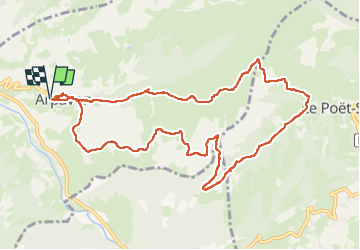

Length
11.8 km

Max alt
801 m

Uphill gradient
368 m
Km-Effort
16.7 km

Min alt
489 m

Downhill gradient
367 m
Boucle
Yes
Creation date :
2025-03-16 08:38:26.0
Updated on :
2025-03-16 13:50:10.747
5h09
Difficulty : Difficult

FREE GPS app for hiking
 SityTrail
IGN / Geographical institutes
SityTrail Plus
The world is yours!
About
Trail Walking of 11.8 km to be discovered at Auvergne-Rhône-Alpes, Drôme, Arpavon. This trail is proposed by raygautier.
Positioning
Country:
France
Region :
Auvergne-Rhône-Alpes
Department/Province :
Drôme
Municipality :
Arpavon
Location:
Unknown
Start:(Dec)
Start:(UTM)
680508 ; 4915489 (31T) N.
Comments