


harre

Benoît Servotte
User
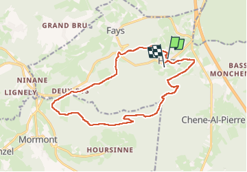

Length
15.4 km

Max alt
481 m

Uphill gradient
451 m
Km-Effort
21 km

Min alt
213 m

Downhill gradient
462 m
Boucle
No
Creation date :
2025-03-16 12:30:36.762
Updated on :
2025-03-16 15:20:23.322
2h49
Difficulty : Easy

FREE GPS app for hiking
 SityTrail
IGN / Geographical institutes
SityTrail Plus
The world is yours!
About
Trail Walking of 15.4 km to be discovered at Wallonia, Luxembourg, Manhay. This trail is proposed by Benoît Servotte.
Positioning
Country:
Belgium
Region :
Wallonia
Department/Province :
Luxembourg
Municipality :
Manhay
Location:
Unknown
Start:(Dec)
Start:(UTM)
689069 ; 5581129 (31U) N.
Comments