


Houyet DEPS

thomarche
User
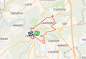

Length
11.8 km

Max alt
268 m

Uphill gradient
259 m
Km-Effort
15.2 km

Min alt
117 m

Downhill gradient
255 m
Boucle
Yes
Creation date :
2025-03-16 12:55:12.0
Updated on :
2025-03-16 15:22:35.385
2h26
Difficulty : Easy

FREE GPS app for hiking
 SityTrail
IGN / Geographical institutes
SityTrail Plus
The world is yours!
About
Trail Walking of 11.8 km to be discovered at Wallonia, Namur, Houyet. This trail is proposed by thomarche.
Description
Chouette deps bcp chemins forêt. Dénivelé. Lesse. RaVel
Positioning
Country:
Belgium
Region :
Wallonia
Department/Province :
Namur
Municipality :
Houyet
Location:
Unknown
Start:(Dec)
Start:(UTM)
643609 ; 5561074 (31U) N.
Comments