


esneux rive 0pposee

annieprairie
User
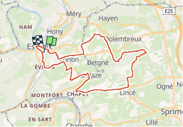

Length
19.1 km

Max alt
285 m

Uphill gradient
458 m
Km-Effort
25 km

Min alt
84 m

Downhill gradient
454 m
Boucle
Yes
Creation date :
2025-03-16 09:08:13.443
Updated on :
2025-03-16 16:00:52.65
5h14
Difficulty : Medium

FREE GPS app for hiking
 SityTrail
IGN / Geographical institutes
SityTrail Plus
The world is yours!
About
Trail Walking of 19.1 km to be discovered at Wallonia, Liège, Esneux. This trail is proposed by annieprairie.
Description
19km
Positioning
Country:
Belgium
Region :
Wallonia
Department/Province :
Liège
Municipality :
Esneux
Location:
Esneux
Start:(Dec)
Start:(UTM)
682289 ; 5600827 (31U) N.
Comments