


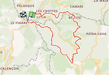
Boucle le Suquet - col de Porte - Beasse

aris
User

Length
23 km

Max alt
1132 m

Uphill gradient
1050 m
Km-Effort
37 km

Min alt
336 m

Downhill gradient
1050 m
Boucle
Yes
Creation date :
2025-03-16 08:01:01.232
Updated on :
2025-03-16 19:43:48.689
8h16
Difficulty : Difficult

FREE GPS app for hiking
 SityTrail
IGN / Geographical institutes
SityTrail Plus
The world is yours!
About
Trail Walking of 23 km to be discovered at Provence-Alpes-Côte d'Azur, Maritime Alps, Lantosque. This trail is proposed by aris.
Positioning
Country:
France
Region :
Provence-Alpes-Côte d'Azur
Department/Province :
Maritime Alps
Municipality :
Lantosque
Location:
Unknown
Start:(Dec)
Start:(UTM)
362201 ; 4866884 (32T) N.
Comments