


rougiers 17 mars 2025

tessonnierg
User
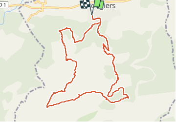

Length
14.1 km

Max alt
619 m

Uphill gradient
464 m
Km-Effort
20 km

Min alt
365 m

Downhill gradient
465 m
Boucle
Yes
Creation date :
2025-03-17 08:49:42.714
Updated on :
2025-03-17 14:34:04.818
5h04
Difficulty : Very difficult

FREE GPS app for hiking
 SityTrail
IGN / Geographical institutes
SityTrail Plus
The world is yours!
About
Trail Walking of 14.1 km to be discovered at Provence-Alpes-Côte d'Azur, Var, Rougiers. This trail is proposed by tessonnierg.
Positioning
Country:
France
Region :
Provence-Alpes-Côte d'Azur
Department/Province :
Var
Municipality :
Rougiers
Location:
Unknown
Start:(Dec)
Start:(UTM)
730689 ; 4808124 (31T) N.
Comments