


pierre percee

noelphil
User
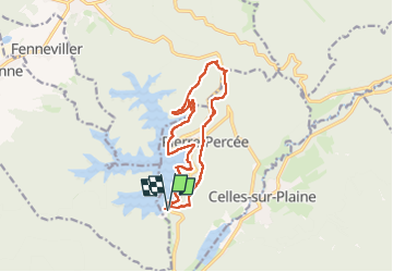

Length
13.6 km

Max alt
498 m

Uphill gradient
334 m
Km-Effort
18 km

Min alt
376 m

Downhill gradient
335 m
Boucle
Yes
Creation date :
2025-02-02 09:33:02.934
Updated on :
2025-03-17 18:31:52.505
4h53
Difficulty : Difficult

FREE GPS app for hiking
 SityTrail
IGN / Geographical institutes
SityTrail Plus
The world is yours!
About
Trail Walking of 13.6 km to be discovered at Grand Est, Meurthe-et-Moselle, Pierre-Percée. This trail is proposed by noelphil.
Positioning
Country:
France
Region :
Grand Est
Department/Province :
Meurthe-et-Moselle
Municipality :
Pierre-Percée
Location:
Unknown
Start:(Dec)
Start:(UTM)
346304 ; 5368860 (32U) N.
Comments