


20250318-Pont de l'Arche Cool

doudet
User
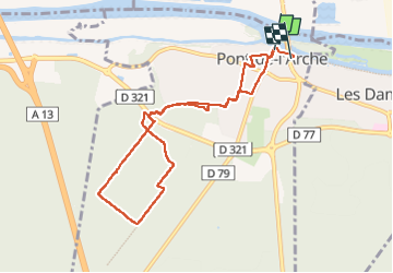

Length
8.2 km

Max alt
64 m

Uphill gradient
113 m
Km-Effort
9.7 km

Min alt
7 m

Downhill gradient
110 m
Boucle
No
Creation date :
2025-03-18 08:35:11.236
Updated on :
2025-03-19 10:17:18.383
2h18
Difficulty : Easy

FREE GPS app for hiking
 SityTrail
IGN / Geographical institutes
SityTrail Plus
The world is yours!
About
Trail Walking of 8.2 km to be discovered at Normandy, Eure, Pont-de-l'Arche. This trail is proposed by doudet.
Description
Boucle A-R au départ du Parking du Camping
Photos

Positioning
Country:
France
Region :
Normandy
Department/Province :
Eure
Municipality :
Pont-de-l'Arche
Location:
Unknown
Start:(Dec)
Start:(UTM)
366013 ; 5463091 (31U) N.
Comments