


Teyssieu mardi 17/3

albert318
User
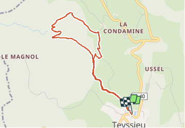

Length
4.6 km

Max alt
422 m

Uphill gradient
115 m
Km-Effort
6.1 km

Min alt
338 m

Downhill gradient
112 m
Boucle
Yes
Creation date :
2025-03-18 13:39:08.611
Updated on :
2025-03-18 15:24:46.526
1h44
Difficulty : Medium

FREE GPS app for hiking
 SityTrail
IGN / Geographical institutes
SityTrail Plus
The world is yours!
About
Trail Walking of 4.6 km to be discovered at Occitania, Lot, Teyssieu. This trail is proposed by albert318.
Description
dans les bois
Positioning
Country:
France
Region :
Occitania
Department/Province :
Lot
Municipality :
Teyssieu
Location:
Unknown
Start:(Dec)
Start:(UTM)
417514 ; 4974502 (31T) N.
Comments