


20150628

fredodlageo
User
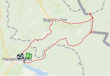

Length
11.2 km

Max alt
409 m

Uphill gradient
310 m
Km-Effort
15.3 km

Min alt
267 m

Downhill gradient
307 m
Boucle
Yes
Creation date :
2015-06-28 00:00:00.0
Updated on :
2015-06-28 00:00:00.0
1h11
Difficulty : Medium

FREE GPS app for hiking
 SityTrail
IGN / Geographical institutes
SityTrail Plus
The world is yours!
About
Trail Mountain bike of 11.2 km to be discovered at Grand Est, Moselle, Haspelschiedt. This trail is proposed by fredodlageo.
Description
étang du camp de bitche
Positioning
Country:
France
Region :
Grand Est
Department/Province :
Moselle
Municipality :
Haspelschiedt
Location:
Unknown
Start:(Dec)
Start:(UTM)
389827 ; 5438068 (32U) N.
Comments