


les ocres de Mormoiron

losjo
User
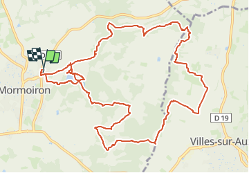

Length
15.3 km

Max alt
372 m

Uphill gradient
325 m
Km-Effort
19.7 km

Min alt
226 m

Downhill gradient
322 m
Boucle
Yes
Creation date :
2025-03-20 09:16:51.254
Updated on :
2025-03-20 09:18:11.569
4h27
Difficulty : Easy

FREE GPS app for hiking
 SityTrail
IGN / Geographical institutes
SityTrail Plus
The world is yours!
About
Trail On foot of 15.3 km to be discovered at Provence-Alpes-Côte d'Azur, Vaucluse, Mormoiron. This trail is proposed by losjo.
Positioning
Country:
France
Region :
Provence-Alpes-Côte d'Azur
Department/Province :
Vaucluse
Municipality :
Mormoiron
Location:
Unknown
Start:(Dec)
Start:(UTM)
675214 ; 4882038 (31T) N.
Comments