


passée communale

randolea
User
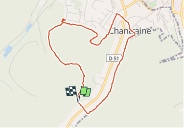

Length
4.6 km

Max alt
459 m

Uphill gradient
98 m
Km-Effort
5.9 km

Min alt
383 m

Downhill gradient
95 m
Boucle
Yes
Creation date :
2025-03-20 08:48:33.12
Updated on :
2025-03-20 10:17:15.495
1h28
Difficulty : Easy

FREE GPS app for hiking
 SityTrail
IGN / Geographical institutes
SityTrail Plus
The world is yours!
About
Trail Walking of 4.6 km to be discovered at Grand Est, Vosges, Chantraine. This trail is proposed by randolea.
Positioning
Country:
France
Region :
Grand Est
Department/Province :
Vosges
Municipality :
Chantraine
Location:
Unknown
Start:(Dec)
Start:(UTM)
308691 ; 5337278 (32U) N.
Comments