


buhl les vignes 11-2024

philou68
User
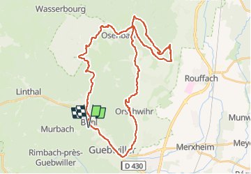

Length
41 km

Max alt
585 m

Uphill gradient
1024 m
Km-Effort
55 km

Min alt
255 m

Downhill gradient
1024 m
Boucle
Yes
Creation date :
2024-11-17 07:57:27.076
Updated on :
2025-03-21 07:41:42.449
3h01
Difficulty : Medium

FREE GPS app for hiking
 SityTrail
IGN / Geographical institutes
SityTrail Plus
The world is yours!
About
Trail Mountain bike of 41 km to be discovered at Grand Est, Haut-Rhin, Buhl. This trail is proposed by philou68.
Positioning
Country:
France
Region :
Grand Est
Department/Province :
Haut-Rhin
Municipality :
Buhl
Location:
Unknown
Start:(Dec)
Start:(UTM)
364670 ; 5309498 (32T) N.
Comments