


Projet_Amicale_Chiroubles_V2

d.rognon
User
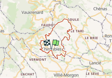

Length
14.3 km

Max alt
522 m

Uphill gradient
459 m
Km-Effort
20 km

Min alt
286 m

Downhill gradient
459 m
Boucle
Yes
Creation date :
2025-03-21 17:34:25.783
Updated on :
2025-03-21 17:38:07.937
4h37
Difficulty : Very difficult

FREE GPS app for hiking
 SityTrail
IGN / Geographical institutes
SityTrail Plus
The world is yours!
About
Trail Walking of 14.3 km to be discovered at Auvergne-Rhône-Alpes, Rhône, Chiroubles. This trail is proposed by d.rognon.
Description
Variante au projet Projet Amicale de 552 m de dénivelé cumulé et d'une longueur de 16.7 kms
Positioning
Country:
France
Region :
Auvergne-Rhône-Alpes
Department/Province :
Rhône
Municipality :
Chiroubles
Location:
Unknown
Start:(Dec)
Start:(UTM)
628516 ; 5115463 (31T) N.
Comments