


HetM 2025

COGLAIS3
User
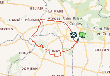

Length
12.2 km

Max alt
120 m

Uphill gradient
78 m
Km-Effort
13.2 km

Min alt
94 m

Downhill gradient
78 m
Boucle
Yes
Creation date :
2025-03-23 14:05:53.627
Updated on :
2025-03-23 16:39:40.329
2h29
Difficulty : Very easy

FREE GPS app for hiking
 SityTrail
IGN / Geographical institutes
SityTrail Plus
The world is yours!
About
Trail Nordic walking of 12.2 km to be discovered at Brittany, Ille-et-Vilaine, Maen-Roch. This trail is proposed by COGLAIS3.
Positioning
Country:
France
Region :
Brittany
Department/Province :
Ille-et-Vilaine
Municipality :
Maen-Roch
Location:
Saint-Brice-en-Coglès
Start:(Dec)
Start:(UTM)
621544 ; 5361542 (30U) N.
Comments