


boismont 27.03.2026

jcb48
User
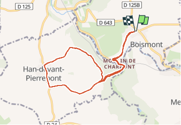

Length
8.6 km

Max alt
305 m

Uphill gradient
158 m
Km-Effort
10.7 km

Min alt
243 m

Downhill gradient
160 m
Boucle
Yes
Creation date :
2025-03-27 13:04:36.448
Updated on :
2025-03-27 15:38:43.185
2h33
Difficulty : Medium

FREE GPS app for hiking
 SityTrail
IGN / Geographical institutes
SityTrail Plus
The world is yours!
About
Trail Walking of 8.6 km to be discovered at Grand Est, Meurthe-et-Moselle, Boismont. This trail is proposed by jcb48.
Description
marche
Positioning
Country:
France
Region :
Grand Est
Department/Province :
Meurthe-et-Moselle
Municipality :
Boismont
Location:
Unknown
Start:(Dec)
Start:(UTM)
698678 ; 5476189 (31U) N.
Comments