


Havlange

fra_depoorter
User
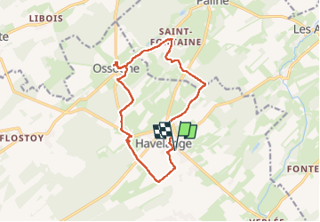

Length
13.1 km

Max alt
319 m

Uphill gradient
253 m
Km-Effort
16.5 km

Min alt
220 m

Downhill gradient
253 m
Boucle
Yes
Creation date :
2025-03-29 08:40:33.687
Updated on :
2025-03-29 11:47:07.686
3h06
Difficulty : Medium

FREE GPS app for hiking
 SityTrail
IGN / Geographical institutes
SityTrail Plus
The world is yours!
About
Trail Walking of 13.1 km to be discovered at Wallonia, Namur, Havelange. This trail is proposed by fra_depoorter.
Positioning
Country:
Belgium
Region :
Wallonia
Department/Province :
Namur
Municipality :
Havelange
Location:
Unknown
Start:(Dec)
Start:(UTM)
659551 ; 5583886 (31U) N.
Comments