


RTT 2015 SAMEDI

Tollard
User
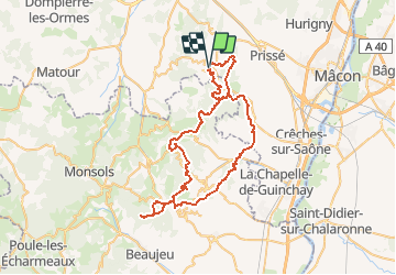

Length
66 km

Max alt
887 m

Uphill gradient
2382 m
Km-Effort
98 km

Min alt
240 m

Downhill gradient
2382 m
Boucle
Yes
Creation date :
2015-08-25 00:00:00.0
Updated on :
2015-08-25 00:00:00.0
6h07
Difficulty : Difficult

FREE GPS app for hiking
 SityTrail
IGN / Geographical institutes
SityTrail Plus
The world is yours!
About
Trail Mountain bike of 66 km to be discovered at Bourgogne-Franche-Comté, Saône-et-Loire, Serrières. This trail is proposed by Tollard.
Description
le plus BEAU parcours (en 20 ans) de pure VTT.
Attention, c'est chaud !!!
Positioning
Country:
France
Region :
Bourgogne-Franche-Comté
Department/Province :
Saône-et-Loire
Municipality :
Serrières
Location:
Unknown
Start:(Dec)
Start:(UTM)
628715 ; 5129913 (31T) N.
Comments