


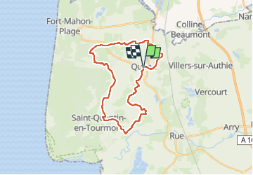
2025-03-30_10h20m05_Somme-Tadorne

nicolas54230
User


0m
Difficulty : Very easy

FREE GPS app for hiking
 SityTrail
IGN / Geographical institutes
SityTrail Plus
The world is yours!
About
Trail Bicycle tourism of 25 km to be discovered at Hauts-de-France, Somme, Quend. This trail is proposed by nicolas54230.
Description
Partez à la découverte d'un territoire surprenant en Baie de Somme et Baie d'Authie et longez le plus vaste massif dunaire du nord de l'Europe. Le circuit est à quelques kilomètres de la gare de Rue, vous pouvez le rejoindre en suivant les indication du circuit de l'avocette.Un itinéraire en arrière pays avec une belle portion sur pistes cyclables.Très proche du Parc du Marquenterre.
Positioning
Comments