


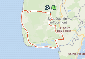
Somme-Marquenterre

nicolas54230
User

Length
15.8 km

Max alt
26 m

Uphill gradient
82 m
Km-Effort
16.9 km

Min alt
0 m

Downhill gradient
85 m
Boucle
Yes
Creation date :
2025-03-30 14:56:23.591
Updated on :
2025-03-30 14:56:46.325
3h50
Difficulty : Difficult

FREE GPS app for hiking
 SityTrail
IGN / Geographical institutes
SityTrail Plus
The world is yours!
About
Trail Walking of 15.8 km to be discovered at Hauts-de-France, Somme, Saint-Quentin-en-Tourmont. This trail is proposed by nicolas54230.
Positioning
Country:
France
Region :
Hauts-de-France
Department/Province :
Somme
Municipality :
Saint-Quentin-en-Tourmont
Location:
Unknown
Start:(Dec)
Start:(UTM)
398886 ; 5571612 (31U) N.
Comments