


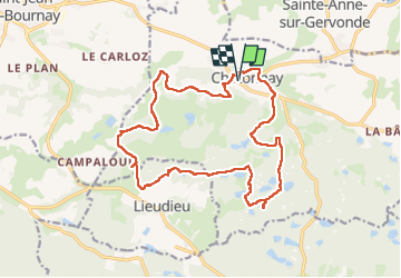
Boucle dans les étangs de Chatonnay - 30 mars 2025

morganee
User

Length
19.1 km

Max alt
568 m

Uphill gradient
411 m
Km-Effort
25 km

Min alt
428 m

Downhill gradient
411 m
Boucle
Yes
Creation date :
2025-03-30 10:06:19.396
Updated on :
2025-03-30 15:53:50.936
5h00
Difficulty : Easy

FREE GPS app for hiking
 SityTrail
IGN / Geographical institutes
SityTrail Plus
The world is yours!
About
Trail Walking of 19.1 km to be discovered at Auvergne-Rhône-Alpes, Isère, Châtonnay. This trail is proposed by morganee.
Positioning
Country:
France
Region :
Auvergne-Rhône-Alpes
Department/Province :
Isère
Municipality :
Châtonnay
Location:
Unknown
Start:(Dec)
Start:(UTM)
672399 ; 5039276 (31T) N.
Comments