


Labeville Park Ecole

avdem
User
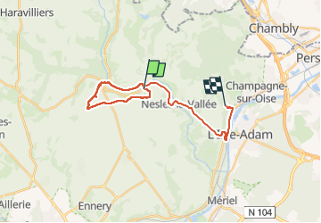

Length
19.2 km

Max alt
111 m

Uphill gradient
264 m
Km-Effort
23 km

Min alt
27 m

Downhill gradient
273 m
Boucle
No
Creation date :
2025-04-01 07:24:39.659
Updated on :
2025-04-01 10:44:17.732
3h18
Difficulty : Easy

FREE GPS app for hiking
 SityTrail
IGN / Geographical institutes
SityTrail Plus
The world is yours!
About
Trail Walking of 19.2 km to be discovered at Ile-de-France, Val-d'Oise, Labbeville. This trail is proposed by avdem.
Description
cool
Positioning
Country:
France
Region :
Ile-de-France
Department/Province :
Val-d'Oise
Municipality :
Labbeville
Location:
Unknown
Start:(Dec)
Start:(UTM)
437582 ; 5442909 (31U) N.
Comments