


Rando Arbonne - coquibus 19km

jeanmarcMasson
User GUIDE
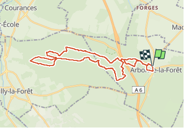

Length
19.3 km

Max alt
138 m

Uphill gradient
220 m
Km-Effort
22 km

Min alt
70 m

Downhill gradient
220 m
Boucle
Yes
Creation date :
2025-04-02 07:58:54.741
Updated on :
2025-04-02 13:32:01.828
4h20
Difficulty : Very difficult

FREE GPS app for hiking
 SityTrail
IGN / Geographical institutes
SityTrail Plus
The world is yours!
About
Trail Walking of 19.3 km to be discovered at Ile-de-France, Seine-et-Marne, Arbonne-la-Forêt. This trail is proposed by jeanmarcMasson.
Positioning
Country:
France
Region :
Ile-de-France
Department/Province :
Seine-et-Marne
Municipality :
Arbonne-la-Forêt
Location:
Unknown
Start:(Dec)
Start:(UTM)
467782 ; 5362438 (31U) N.
Comments