


aingeray

ISAGIL
User
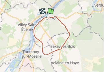

Length
10.4 km

Max alt
267 m

Uphill gradient
124 m
Km-Effort
12 km

Min alt
192 m

Downhill gradient
122 m
Boucle
Yes
Creation date :
2025-04-03 12:04:05.832
Updated on :
2025-04-03 14:57:50.775
2h52
Difficulty : Difficult

FREE GPS app for hiking
 SityTrail
IGN / Geographical institutes
SityTrail Plus
The world is yours!
About
Trail Walking of 10.4 km to be discovered at Grand Est, Meurthe-et-Moselle, Aingeray. This trail is proposed by ISAGIL.
Description
aingeray
Positioning
Country:
France
Region :
Grand Est
Department/Province :
Meurthe-et-Moselle
Municipality :
Aingeray
Location:
Unknown
Start:(Dec)
Start:(UTM)
279497 ; 5402841 (32U) N.
Comments