


col du chat

jpgo73
User
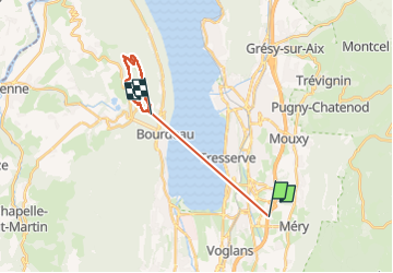

Length
17 km

Max alt
757 m

Uphill gradient
899 m
Km-Effort
28 km

Min alt
230 m

Downhill gradient
542 m
Boucle
No
Creation date :
2025-04-02 12:00:54.666
Updated on :
2025-04-04 12:30:15.668
3h16
Difficulty : Very easy

FREE GPS app for hiking
 SityTrail
IGN / Geographical institutes
SityTrail Plus
The world is yours!
About
Trail Nordic walking of 17 km to be discovered at Auvergne-Rhône-Alpes, Savoy, Méry. This trail is proposed by jpgo73.
Positioning
Country:
France
Region :
Auvergne-Rhône-Alpes
Department/Province :
Savoy
Municipality :
Méry
Location:
Unknown
Start:(Dec)
Start:(UTM)
727705 ; 5059014 (31T) N.
Comments