


crozon Pen hir cath

coglais
User
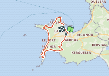

Length
11.9 km

Max alt
57 m

Uphill gradient
220 m
Km-Effort
14.8 km

Min alt
0 m

Downhill gradient
220 m
Boucle
Yes
Creation date :
2025-04-04 07:53:43.945
Updated on :
2025-05-16 09:29:57.658
3h06
Difficulty : Very easy

FREE GPS app for hiking
 SityTrail
IGN / Geographical institutes
SityTrail Plus
The world is yours!
About
Trail Nordic walking of 11.9 km to be discovered at Brittany, Finistère, Camaret-sur-Mer. This trail is proposed by coglais.
Positioning
Country:
France
Region :
Brittany
Department/Province :
Finistère
Municipality :
Camaret-sur-Mer
Location:
Unknown
Start:(Dec)
Start:(UTM)
381609 ; 5347833 (30U) N.
Comments