


Mur de la peste

denel
User
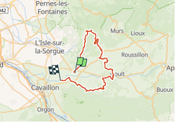

Length
57 km

Max alt
638 m

Uphill gradient
1298 m
Km-Effort
74 km

Min alt
83 m

Downhill gradient
1309 m
Boucle
No
Creation date :
2025-04-05 06:53:36.452
Updated on :
2025-04-05 12:21:25.883
3h27
Difficulty : Difficult

FREE GPS app for hiking
 SityTrail
IGN / Geographical institutes
SityTrail Plus
The world is yours!
About
Trail Mountain bike of 57 km to be discovered at Provence-Alpes-Côte d'Azur, Vaucluse, Robion. This trail is proposed by denel.
Description
Best randonnée
Positioning
Country:
France
Region :
Provence-Alpes-Côte d'Azur
Department/Province :
Vaucluse
Municipality :
Robion
Location:
Unknown
Start:(Dec)
Start:(UTM)
670604 ; 4859075 (31T) N.
Comments