


guise

Ty Mrlt
User
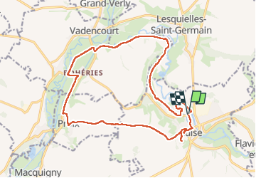

Length
18.3 km

Max alt
149 m

Uphill gradient
210 m
Km-Effort
21 km

Min alt
83 m

Downhill gradient
212 m
Boucle
Yes
Creation date :
2025-04-05 09:29:41.085
Updated on :
2025-04-05 13:49:07.338
4h18
Difficulty : Difficult

FREE GPS app for hiking
 SityTrail
IGN / Geographical institutes
SityTrail Plus
The world is yours!
About
Trail Walking of 18.3 km to be discovered at Hauts-de-France, Aisne, Guise. This trail is proposed by Ty Mrlt.
Photos


Positioning
Country:
France
Region :
Hauts-de-France
Department/Province :
Aisne
Municipality :
Guise
Location:
Unknown
Start:(Dec)
Start:(UTM)
544917 ; 5528152 (31U) N.
Comments