


2025 04 05 Velocio Guizay AR

OLYMP42
User
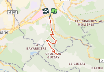

Length
6.7 km

Max alt
880 m

Uphill gradient
287 m
Km-Effort
10.6 km

Min alt
589 m

Downhill gradient
286 m
Boucle
Yes
Creation date :
2025-04-05 12:01:49.611
Updated on :
2025-04-05 14:00:04.988
1h58
Difficulty : Medium

FREE GPS app for hiking
 SityTrail
IGN / Geographical institutes
SityTrail Plus
The world is yours!
About
Trail Walking of 6.7 km to be discovered at Auvergne-Rhône-Alpes, Loire, Saint-Étienne. This trail is proposed by OLYMP42.
Positioning
Country:
France
Region :
Auvergne-Rhône-Alpes
Department/Province :
Loire
Municipality :
Saint-Étienne
Location:
Unknown
Start:(Dec)
Start:(UTM)
609408 ; 5029430 (31T) N.
Comments