


Treignes Rando du 4 avril ANC

Tommy Eric
User
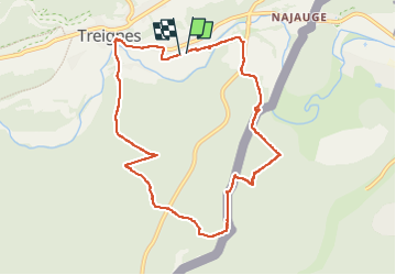

Length
8.9 km

Max alt
305 m

Uphill gradient
313 m
Km-Effort
13.1 km

Min alt
121 m

Downhill gradient
315 m
Boucle
Yes
Creation date :
2025-04-05 11:11:55.258
Updated on :
2025-04-05 14:35:58.652
3h23
Difficulty : Difficult

FREE GPS app for hiking
 SityTrail
IGN / Geographical institutes
SityTrail Plus
The world is yours!
About
Trail Walking of 8.9 km to be discovered at Wallonia, Namur, Viroinval. This trail is proposed by Tommy Eric.
Positioning
Country:
Belgium
Region :
Wallonia
Department/Province :
Namur
Municipality :
Viroinval
Location:
Unknown
Start:(Dec)
Start:(UTM)
620276 ; 5550042 (31U) N.
Comments