


Tulle vélo

cps46
User
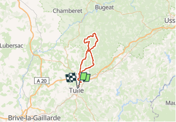

Length
75 km

Max alt
851 m

Uphill gradient
1357 m
Km-Effort
93 km

Min alt
217 m

Downhill gradient
1357 m
Boucle
No
Creation date :
2025-04-06 07:31:00.0
Updated on :
2025-04-06 10:54:50.644

FREE GPS app for hiking
 SityTrail
IGN / Geographical institutes
SityTrail Plus
The world is yours!
About
Trail of 75 km to be discovered at New Aquitaine, Corrèze, Tulle. This trail is proposed by cps46.
Positioning
Country:
France
Region :
New Aquitaine
Department/Province :
Corrèze
Municipality :
Tulle
Location:
Unknown
Start:(Dec)
Start:(UTM)
404595 ; 5014546 (31T) N.
Comments