


Aujargues 250406

Dupuybadonniere
User
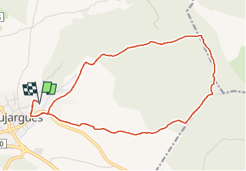

Length
5.4 km

Max alt
142 m

Uphill gradient
75 m
Km-Effort
6.4 km

Min alt
78 m

Downhill gradient
75 m
Boucle
Yes
Creation date :
2025-04-06 12:01:45.14
Updated on :
2025-04-06 13:31:17.506
1h22
Difficulty : Medium

FREE GPS app for hiking
 SityTrail
IGN / Geographical institutes
SityTrail Plus
The world is yours!
About
Trail Walking of 5.4 km to be discovered at Occitania, Gard, Aujargues. This trail is proposed by Dupuybadonniere.
Positioning
Country:
France
Region :
Occitania
Department/Province :
Gard
Municipality :
Aujargues
Location:
Unknown
Start:(Dec)
Start:(UTM)
590527 ; 4849286 (31T) N.
Comments