


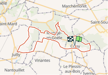
Les rus de Goële et la forêt de Montgé

Gathobaz
User

Length
19 km

Max alt
209 m

Uphill gradient
257 m
Km-Effort
22 km

Min alt
84 m

Downhill gradient
258 m
Boucle
Yes
Creation date :
2025-04-07 08:43:11.33
Updated on :
2025-04-07 09:46:58.479
5h05
Difficulty : Very difficult

FREE GPS app for hiking
 SityTrail
IGN / Geographical institutes
SityTrail Plus
The world is yours!
About
Trail Walking of 19 km to be discovered at Ile-de-France, Seine-et-Marne, Cuisy. This trail is proposed by Gathobaz.
Points of interest


Positioning
Country:
France
Region :
Ile-de-France
Department/Province :
Seine-et-Marne
Municipality :
Cuisy
Location:
Unknown
Start:(Dec)
Start:(UTM)
483328 ; 5429766 (31U) N.
Comments