


Apremont la Forêt

kikkko
User
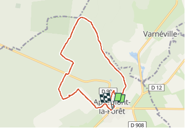

Length
7.5 km

Max alt
379 m

Uphill gradient
150 m
Km-Effort
9.5 km

Min alt
259 m

Downhill gradient
148 m
Boucle
Yes
Creation date :
2025-04-07 07:26:25.188
Updated on :
2025-04-07 09:59:42.695
1h58
Difficulty : Medium

FREE GPS app for hiking
 SityTrail
IGN / Geographical institutes
SityTrail Plus
The world is yours!
About
Trail Walking of 7.5 km to be discovered at Grand Est, Meuse, Apremont-la-Forêt. This trail is proposed by kikkko.
Description
joli promenade en Forêt avec vestiges de la Guerre
Positioning
Country:
France
Region :
Grand Est
Department/Province :
Meuse
Municipality :
Apremont-la-Forêt
Location:
Apremont-la-Forêt
Start:(Dec)
Start:(UTM)
693635 ; 5414666 (31U) N.
Comments