


mery fournet revert

Berquier
User
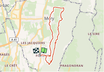

Length
8.1 km

Max alt
495 m

Uphill gradient
273 m
Km-Effort
11.8 km

Min alt
308 m

Downhill gradient
273 m
Boucle
Yes
Creation date :
2025-04-07 12:00:48.648
Updated on :
2025-04-07 15:06:56.971
3h05
Difficulty : Medium

FREE GPS app for hiking
 SityTrail
IGN / Geographical institutes
SityTrail Plus
The world is yours!
About
Trail Walking of 8.1 km to be discovered at Auvergne-Rhône-Alpes, Savoy, Méry. This trail is proposed by Berquier .
Positioning
Country:
France
Region :
Auvergne-Rhône-Alpes
Department/Province :
Savoy
Municipality :
Méry
Location:
Unknown
Start:(Dec)
Start:(UTM)
728563 ; 5056771 (31T) N.
Comments