


mauresque

ISAGIL
User
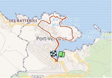

Length
4.6 km

Max alt
48 m

Uphill gradient
85 m
Km-Effort
5.7 km

Min alt
-2 m

Downhill gradient
80 m
Boucle
Yes
Creation date :
2025-04-09 11:58:25.227
Updated on :
2025-04-09 14:09:04.296
2h09
Difficulty : Easy

FREE GPS app for hiking
 SityTrail
IGN / Geographical institutes
SityTrail Plus
The world is yours!
About
Trail Walking of 4.6 km to be discovered at Occitania, Pyrénées-Orientales, Port-Vendres. This trail is proposed by ISAGIL.
Description
mauresque
Positioning
Country:
France
Region :
Occitania
Department/Province :
Pyrénées-Orientales
Municipality :
Port-Vendres
Location:
Unknown
Start:(Dec)
Start:(UTM)
508810 ; 4707051 (31T) N.
Comments