


Projet Amicale Ste Croix en Jarez

d.rognon
User
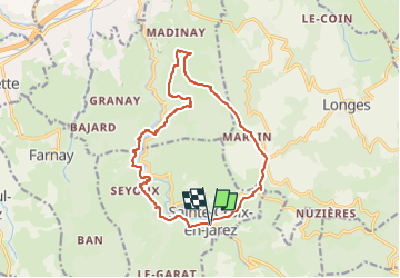

Length
14.9 km

Max alt
618 m

Uphill gradient
424 m
Km-Effort
21 km

Min alt
353 m

Downhill gradient
432 m
Boucle
Yes
Creation date :
2025-04-10 06:45:29.086
Updated on :
2025-04-10 06:47:27.949
4h40
Difficulty : Very difficult

FREE GPS app for hiking
 SityTrail
IGN / Geographical institutes
SityTrail Plus
The world is yours!
About
Trail Walking of 14.9 km to be discovered at Auvergne-Rhône-Alpes, Loire, Sainte-Croix-en-Jarez. This trail is proposed by d.rognon.
Description
Selon une proposition de AltitudeRando
Positioning
Country:
France
Region :
Auvergne-Rhône-Alpes
Department/Province :
Loire
Municipality :
Sainte-Croix-en-Jarez
Location:
Unknown
Start:(Dec)
Start:(UTM)
628692 ; 5037410 (31T) N.
Comments