Trail Mountain bike Vallon-Pont-d'Arc - SP2015 reco - Photo
© OpenStreetMap contributors
Length
Length
25 km
Max alt
Max alt
279 m
Uphill gradient
Uphill gradient
467 m
Km-Effort
Km-Effort  
31 km
Min alt
Min alt
79 m
Downhill gradient
Downhill gradient
468 m
Boucle
Boucle
Yes
Creation date :
2025-04-10 12:58:37.029
Updated on :
2025-04-10 15:23:35.488

(0 Reviews)

Mountain bike
Mountain bike
2h24
Difficulty : Difficult

Scan this QR Code to open this trail in the SityTrail application

FREE GPS app for hiking

Logo SityTrail SityTrail

IGN / Geographical institutes

Download SityTrail from the App Store Download SityTrail from Google Play

Logo SityTrail SityTrail Plus

The world is yours!

Download SityTrail from the App Store Download SityTrail from Google Play Download SityTrail on Huawei AppGallery

About

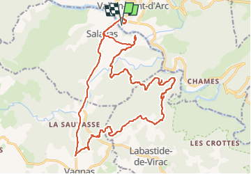
Trail Mountain bike of 25 km to be discovered at Auvergne-Rhône-Alpes, Ardèche, Vallon-Pont-d'Arc. This trail is proposed by PhilippeC54.

Elevation profile

Points of interest

Point of interest Salavas - Unnamed POI - Photo
PhilippeC54
SALAVAS 
Point of interest Salavas - Unnamed POI - Photo
PhilippeC54
SALAVAS 
Point of interest Labastide-de-Virac - Unnamed POI - Photo
PhilippeC54
LABASTIDE-DE-VIRAC 
Point of interest Labastide-de-Virac - Unnamed POI - Photo
PhilippeC54
LABASTIDE-DE-VIRAC 

Positioning

Country:
France
Region :
Auvergne-Rhône-Alpes
Department/Province :
Ardèche
Municipality :
Vallon-Pont-d'Arc
Location:
Unknown
Start:(UTM)
610501 ; 4917039 (31T) N.


Close
My subscriptions