


pourcheres

raygautier
User
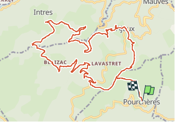

Length
17.1 km

Max alt
848 m

Uphill gradient
713 m
Km-Effort
27 km

Min alt
519 m

Downhill gradient
696 m
Boucle
Yes
Creation date :
2025-04-10 07:22:15.93
Updated on :
2025-04-10 17:46:38.255
7h20
Difficulty : Very difficult

FREE GPS app for hiking
 SityTrail
IGN / Geographical institutes
SityTrail Plus
The world is yours!
About
Trail Walking of 17.1 km to be discovered at Auvergne-Rhône-Alpes, Ardèche, Pourchères. This trail is proposed by raygautier.
Positioning
Country:
France
Region :
Auvergne-Rhône-Alpes
Department/Province :
Ardèche
Municipality :
Pourchères
Location:
Unknown
Start:(Dec)
Start:(UTM)
619249 ; 4955931 (31T) N.
Comments