


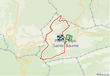
Plan d'Aups-Sainte Baume

FSantoni
User


6h17
Difficulty : Very difficult

FREE GPS app for hiking
 SityTrail
IGN / Geographical institutes
SityTrail Plus
The world is yours!
About
Trail Walking of 15.4 km to be discovered at Provence-Alpes-Côte d'Azur, Var, Plan-d'Aups-Sainte-Baume. This trail is proposed by FSantoni.
Description
15 km pour un dénivelé de 500 mètres au départ de plan d'Aups-Sainte Baume, vers le col de Bertagne, le vallon du Cros, la grotte du Védi. Au km 6,5, passage par un chemin annoncé comme privé....
Des privatisations de plus en plus nombreuses sur des chemins anciennement balisés...
Photos


24 photos in total. Please click on a photo to see them all in the gallery.
Positioning
Comments