


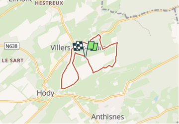
Boucle du Thier de Villers aux Tours

psyberty
User

Length
5.7 km

Max alt
295 m

Uphill gradient
96 m
Km-Effort
7 km

Min alt
238 m

Downhill gradient
99 m
Boucle
Yes
Creation date :
2025-04-11 15:35:52.678
Updated on :
2025-04-11 15:38:54.616
1h35
Difficulty : Medium

FREE GPS app for hiking
 SityTrail
IGN / Geographical institutes
SityTrail Plus
The world is yours!
About
Trail Walking of 5.7 km to be discovered at Wallonia, Liège, Anthisnes. This trail is proposed by psyberty.
Description
promenade sur des chemins d'où on découvre la vallée de Villers et d'Anthisnes.
Traversée du village de Villers aux Tours..
Positioning
Country:
Belgium
Region :
Wallonia
Department/Province :
Liège
Municipality :
Anthisnes
Location:
Unknown
Start:(Dec)
Start:(UTM)
678371 ; 5596662 (31U) N.
Comments