


Tour Caluire

isyvon
User
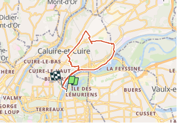

Length
11.5 km

Max alt
269 m

Uphill gradient
188 m
Km-Effort
13.9 km

Min alt
166 m

Downhill gradient
182 m
Boucle
No
Creation date :
2025-04-13 06:47:57.115
Updated on :
2025-04-13 06:57:12.203
3h10
Difficulty : Easy

FREE GPS app for hiking
 SityTrail
IGN / Geographical institutes
SityTrail Plus
The world is yours!
About
Trail On foot of 11.5 km to be discovered at Auvergne-Rhône-Alpes, Métropole de Lyon, Lyon. This trail is proposed by isyvon.
Positioning
Country:
France
Region :
Auvergne-Rhône-Alpes
Department/Province :
Métropole de Lyon
Municipality :
Lyon
Location:
Lyon 6e Arrondissement
Start:(Dec)
Start:(UTM)
643373 ; 5070916 (31T) N.
Comments