


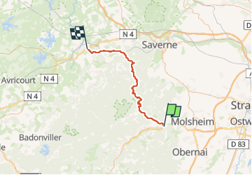
de urmatt à buhl cabane marie

Titinechris
User

Length
50 km

Max alt
956 m

Uphill gradient
1556 m
Km-Effort
71 km

Min alt
213 m

Downhill gradient
1512 m
Boucle
No
Creation date :
2025-04-13 10:03:41.658
Updated on :
2025-04-13 10:04:52.352
10h00
Difficulty : Medium

FREE GPS app for hiking
 SityTrail
IGN / Geographical institutes
SityTrail Plus
The world is yours!
About
Trail Trail of 50 km to be discovered at Grand Est, Bas-Rhin, Heiligenberg. This trail is proposed by Titinechris.
Positioning
Country:
France
Region :
Grand Est
Department/Province :
Bas-Rhin
Municipality :
Heiligenberg
Location:
Unknown
Start:(Dec)
Start:(UTM)
380469 ; 5376504 (32U) N.
Comments