


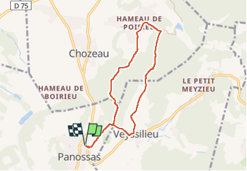
Panossas

jean52
User

Length
7.1 km

Max alt
369 m

Uphill gradient
225 m
Km-Effort
10.1 km

Min alt
255 m

Downhill gradient
224 m
Boucle
Yes
Creation date :
2025-04-14 06:58:20.0
Updated on :
2025-04-14 08:34:34.025
1h23
Difficulty : Unknown

FREE GPS app for hiking
 SityTrail
IGN / Geographical institutes
SityTrail Plus
The world is yours!
About
Trail Nordic walking of 7.1 km to be discovered at Auvergne-Rhône-Alpes, Isère, Panossas. This trail is proposed by jean52.
Positioning
Country:
France
Region :
Auvergne-Rhône-Alpes
Department/Province :
Isère
Municipality :
Panossas
Location:
Unknown
Start:(Dec)
Start:(UTM)
671893 ; 5060714 (31T) N.
Comments