


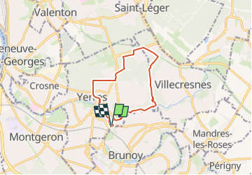
BM Yerres Réveillon 10km

jeanmarcMasson
User GUIDE

Length
9.7 km

Max alt
117 m

Uphill gradient
137 m
Km-Effort
11.6 km

Min alt
37 m

Downhill gradient
137 m
Boucle
Yes
Creation date :
2025-04-19 12:13:16.0
Updated on :
2025-04-22 07:19:30.43
2h37
Difficulty : Medium

FREE GPS app for hiking
 SityTrail
IGN / Geographical institutes
SityTrail Plus
The world is yours!
About
Trail Walking of 9.7 km to be discovered at Ile-de-France, Essonne, Yerres. This trail is proposed by jeanmarcMasson.
Description
Départ : parking des 2 rivières
Positioning
Country:
France
Region :
Ile-de-France
Department/Province :
Essonne
Municipality :
Yerres
Location:
Unknown
Start:(Dec)
Start:(UTM)
463033 ; 5395043 (31U) N.
Comments