


Boucle à partir du village de Chanly

xtislair
User
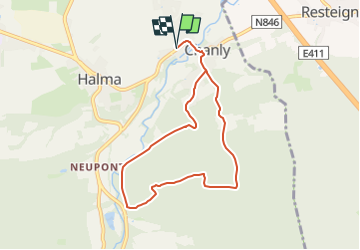

Length
7.1 km

Max alt
359 m

Uphill gradient
230 m
Km-Effort
10.2 km

Min alt
188 m

Downhill gradient
231 m
Boucle
Yes
Creation date :
2025-04-20 13:05:10.091
Updated on :
2025-04-20 13:05:59.189
2h18
Difficulty : Easy

FREE GPS app for hiking
 SityTrail
IGN / Geographical institutes
SityTrail Plus
The world is yours!
About
Trail On foot of 7.1 km to be discovered at Wallonia, Luxembourg, Wellin. This trail is proposed by xtislair.
Positioning
Country:
Belgium
Region :
Wallonia
Department/Province :
Luxembourg
Municipality :
Wellin
Location:
Unknown
Start:(Dec)
Start:(UTM)
653876 ; 5549619 (31U) N.
Comments