JARDINS DE DIANE/PASTOURELLE

Michel DUBOIS
User
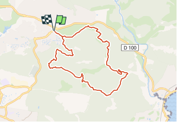

Length
9.4 km

Max alt
143 m

Uphill gradient
304 m
Km-Effort
13.5 km

Min alt
18 m

Downhill gradient
304 m
Boucle
Yes
Creation date :
2025-04-20 17:22:58.932
Updated on :
2025-04-20 17:26:09.689
3h03
Difficulty : Medium

FREE GPS app for hiking
 SityTrail
IGN / Geographical institutes
SityTrail Plus
The world is yours!
About
Trail Walking of 9.4 km to be discovered at Provence-Alpes-Côte d'Azur, Var, Saint-Raphaël. This trail is proposed by Michel DUBOIS.
Positioning
Country:
France
Region :
Provence-Alpes-Côte d'Azur
Department/Province :
Var
Municipality :
Saint-Raphaël
Location:
Unknown
Start:(Dec)
Start:(UTM)
323472 ; 4813045 (32T) N.
Comments