


Piste_GEODE

PhilippeC54
User

Length
20 km

Max alt
319 m

Uphill gradient
221 m
Km-Effort
23 km

Min alt
213 m

Downhill gradient
222 m
Boucle
Yes
Creation date :
2025-04-21 09:56:05.294
Updated on :
2025-04-23 08:00:37.515
1h36
Difficulty : Medium

FREE GPS app for hiking
 SityTrail
IGN / Geographical institutes
SityTrail Plus
The world is yours!
About
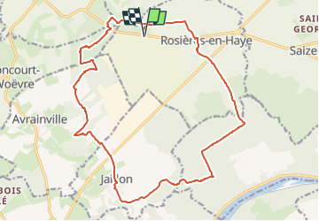
Trail Mountain bike of 20 km to be discovered at Grand Est, Meurthe-et-Moselle, Rosières-en-Haye. This trail is proposed by PhilippeC54.
Positioning
Country:
France
Region :
Grand Est
Department/Province :
Meurthe-et-Moselle
Municipality :
Rosières-en-Haye
Location:
Unknown
Start:(Dec)
Start:(UTM)
718791 ; 5408914 (31U) N.
Comments